Collections
| Back New Search Tips |
Playfair Locator Map
|
| Accession #: | 4068.1 |
|---|---|
| Title: | Playfair Locator Map |
| Object Type: | Map |
| Participants: | |
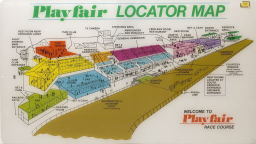
| Physical Description: | This Plexiglas map with (paper?) lamination shows the location of all of the public areas of the Playfair racetrack, these are in various colors. There are three mounting holes on each vertical side. |
| Description: | During it peak, Playfair Race Course opened new box seats and a private Turf Club, drawn on this 1960s sign. First opened in 1901 with an architect-designed grandstand, the Spokane Interstate Fair typically included six days of horse racing, its derby a premier event. Desperate for income during the Great Depression, states reversed earlier gambling reforms, and Spokane's grandstand re-opened as Playfair. Popular interest boomed through the 1970s, then followed a national pattern of decline, with demolition in 2004. |
| Category: | History |
| Subjects/Topics/Concepts: |
Recreation
|
| Geographical Reference: | Spokane (Washington->Spokane County) |
| Dimensions: |
height 24"
length 42"
|
| Materials/Techniques: |
plastic (organic material) (
paper (fiber product) (
Plexiglas (TM) ( |
| Marks/Inscription: |
“Playfair Locator Map Welcome to Playfair Race Course” and many and varied inscriptions describing attributes and locations at Playfair.
|
| Related Exhibits: | |
| Credit Line: | Gift of the Pring Family |
To order a reproduction, inquire about permissions, or for information about prices see:
https://www.northwestmuseum.org/collections